
YAMPA RIVER LEAFY SPURGE PROJECT
Field Mapping
HINT: Clicking on any map on this page will open a higher resolution PDF version, which can then be zoomed, printed, or downloaded. PDF map files posted to this website are designed to reveal excellent detail when zoomed to 400%. This is particularly useful for viewing our leafy spurge maps, where the leafy spurge infestations are all represented to scale.
Our leafy spurge mapping data are now displayed in our new Interactive Map application, or can be downloaded HERE.
Introduction
From its inception in 2015, the Yampa River Leafy Spurge Project has recognized the importance of documenting the extent and degree of the leafy spurge infestations in the Yampa River's riparian corridors. John Husband first got the ball rolling when he floated the Little Yampa Canyon in July 2016. John recorded a mile-by-mile inventory of the leafy spurge that he could see from his boat, while marking the locations on a set of paper maps. These maps and his inventory report are now archived HERE.
Dinosaur National Monument also began conducting an inventory of leafy spurge within its boundaries in 2016, after observing an explosion of infestation in the years immediately following the high water events of 2011. Using digital GIS mapping technology, the monument's resource management team created a comprehensive dataset for infestations along the Yampa River, and along the Green River downstream of its confluence with the Yampa (leafy spurge has not yet been observed in the Canyon of Lodore). The Yampa River results were compiled in 2018, and appear in the Dinosaur National Monument series. (It must be noted that during the years since 2018 the leafy spurge populations within the monument have continued to increase dramatically, and these maps are now significantly out of date.)
Using the Dinosaur National Monument GIS methodology as its model, in 2019 the YRLSP then began its own project to map leafy spurge in the riparian corridors of the upper Yampa River. The first mapping season addressed the Yampa reaches from the town of Hayden downstream through the Little Yampa Canyon—approximately 60 miles of the river were completed that summer.
In 2020 an additional 50 miles were completed, from the mouth of the Little Yampa Canyon downstream to the head of Cross Mountain Canyon. Additional mapping in the Yampa River State Wildlife Area was also performed, as well as the mapping of a large infestation on Bureau of Land Management lands in upper Tepee Draw, north of Dinosaur National Monument (the current Tepee Draw map is now included in the Dinosaur National Monument series).
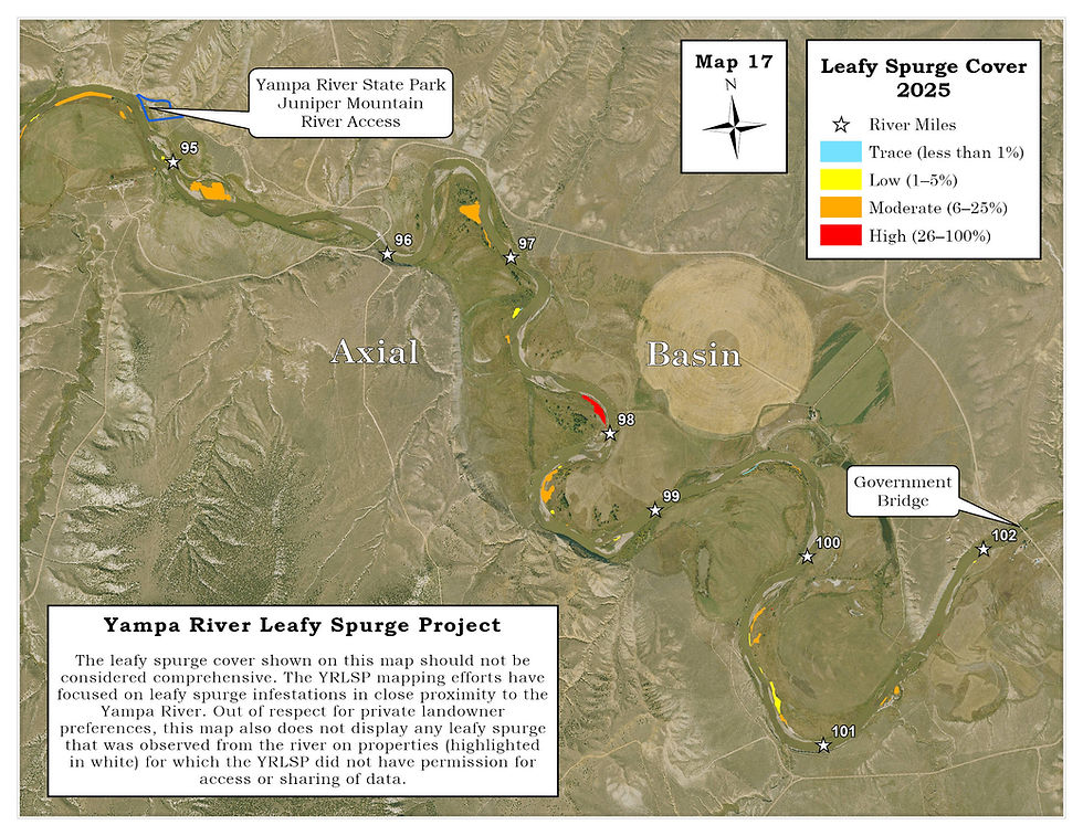
A six-mile stretch of the Yampa River in the Axial Basin, missed during the 2020 mapping effort, was completed in June 2021, and in 2022 the last remaining unmapped reach of the project was completed, between Cross Mountain and Dinosaur National Monument.
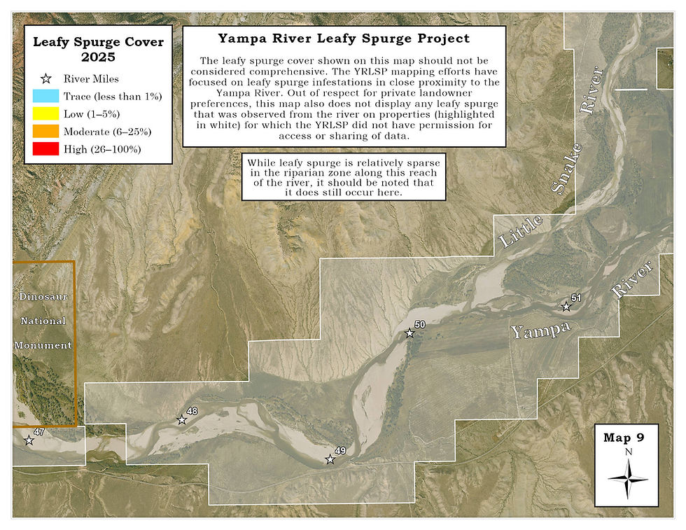
Since 2022, the YRLSP has continued to update their leafy spurge field mapping data throughout the reaches upstream of Dinosaur National Monument. In 2025 the entire series of maps from Dinosaur to Hayden (Maps 9–27) were republished to show the current data and the most recent background photography available from the National Agriculture Imaging Program (2023). Supplemental field mapping in previously mapped reaches will continue into the future.
The YRLSP mapping data is published in the following three series—Dinosaur to Maybell, Axial Basin/Little Yampa Canyon, and Craig to Hayden.
YRLSP's field mapping data has also made an important contribution to University of Wyoming graduate student Chloe Mattilio's development of a Remote Sensing application for detecting leafy spurge infestations across the entire Yampa River Basin.
Our thanks to the many landowners along the river who have graciously allowed us access to their properties for the mapping project.
Field Maps

Mapping leafy spurge in the Little Yampa Canyon.
Key to Detailed Field Maps

Dinosaur National Monument Series
(Maps 1–8, and Tepee Draw)


Dinosaur to Maybell Series
(Maps 9–15)


Axial Basin/Little Yampa Canyon Series
(Maps 16–22)


Craig to Hayden Series
(Maps 23–27)


